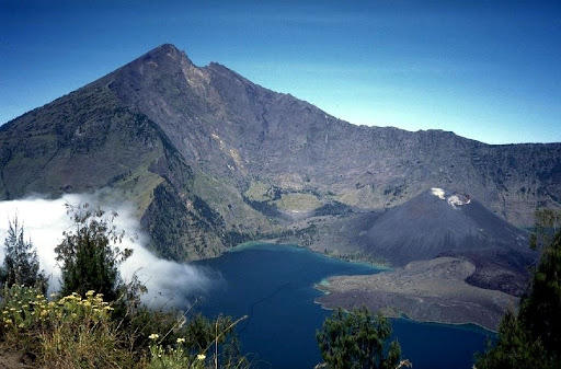
Mount Rinjani having 3,726 meters (12,224 feet) height on the island of Lombok in Indonesia is not only the second-tallest volcano in the country, but also one of the best-known natural marvels in Southeast Asia. It has been a place of fascination to explorers, pilgrims and nature lovers all across the globe due to just a few reasons in its stunning beauty, rich cultural heritage and a dramatic history of volcanoes.
My article will elaborate on the history and the geography and the conservation processes of the region that make Mount Rinjani present the characteristics of a remarkable site and an ecotourism site well respected the world over.
Spiritual Heritage
Mount Rinjani has been a highly spiritual place to both the Sasak and Balinese people, who were indigenous to the mountain, over the centuries. They worship the volcano as the sacred world which is occupied by the spirits of ancestors. The core of this worship is the deep-blue lake called Lake Segara Anak that is located in the huge caldera of Rinjani.
This lake of tranquility has been a pilgrimage centre and ritual. To perform rituals to the guardian spirits of the mountain and integrate the centuries old traditions with awe-inspiring natural scenery, the Sasak and Balinese people come to pay tribute to it.
A Volcanic History
The geological history of Mount Rinjani is characterized by intense eruptions that have created it to be a rugged mountain. It has two volcanic eruptions in 1257 and 1847.
- The 1257 eruption has been termed as one of the strongest eruptions that have been experienced in history. It was not only very extensive in Indonesia: due to the release of volcanic ash into the atmosphere in large quantities, a global-scale volcanic winter took place, crippling agriculture in Europe and other parts of the world.
- Later eruptions such as the one in 1847 were used to carve out the massive caldera which is present today to shape the basin where Segara Anak Lake now rests.
The geological processes left a trace of spectacular cliffs, fertile valleys, and other unearthly volcanic structures that have transformed Mount Rinjani into a masterpiece in the eyes.
A Safeguarded Haven
The Indonesian government identity of ecological and cultural significance and thereby mounted Rinjani and its ecosystem as a national park in 1990. It covers an area of over 41, 000 hectares and is under management of the ministry of environment and forestry and is known as Gunung Rinjani National Park.
The creation of the park was a significant move to protect the biodiversity of the region, its tropical forests, original flora and fauna as well as the need to balance the increasing ecotourism pressure.
Tourism and Conservation
Mount Rinjani has become one of the most popular trekking spots of Indonesia. Each year thousands of people hike its trails to see its sweeping views, lakes in the craters and the challenge of summiting on the high peak.
In order to safeguard the mountain as the number of people visiting it rises, a number of management plans have been resolved:
- There are strict waste management regulations that will mean that there is minimal environmental impact.
- The local community participation ensures that tourism is of value to the people in the area with preservation of culture.
This sustainable co-operation model can contribute to sustainable tourism, which will mainly keep the natural beauty of Rinjani intact.
Geography and Climate
The West Nusa Tenggara province is dominated by Mount Rinjani. Geographical features it has include:
- Dense tropical forests.
- Steep volcanic ridges on the hiking tracks.
- A caldera containing Segara Anak Lake spans 6 kilometers wide and occupies 1,100 hectares and 200 meters deep in the lake.
Lombok’s tropical climate brings:
- Wet season: November to April
- Dry season: May through October (best trekking season since trails are clear and there is good weather)
It is warm at lower altitudes but the temperatures at the top may plummet at night and this demands adequate preparation of trekkers.
Zoning: The Sustainable Protection Strategy
Gunung Rinjani National Park consists of five major zones which play certain ecological and cultural roles:
1. Core Zone
The highest point, caldera, and Segara Anak Lake are the most secure zone. It is not allowed to develop so that it can still remain in its natural purity.
2. Buffer Zone
A buffer zone where limited activities like scientific research and education on the environment could be undertaken in order to protect the core zone against human activities.
3. Utilization Zone
Marked as ecotourism -trekking, camping and sightseeing. The numbers of visitors, dumping of waste and trail use are closely checked.
4. Traditional Use Zone
The park was reserved to cultural rituals that were conducted by the Sasak and the Balinese who believed that they had a connection to ancestral relationship with the mountain.
5. Rehabilitation Zone
Regions where there is erosion, volcanoes or manmade damages. The efforts are directed at reforestation and natural ecosystem restoration.
Conclusion
Mount Rinjani is an impressive evidence of the Indonesian natural beauty, cultural diversity, and geology. It is not just a hiking place but a holy territory, which is being molded by a centuries-long tradition and natural selection. Mount Rinjani can provide the spiritual, historical and adventure adventures of a lifetime and is a place to experience the best things in the middle of the volcanic splendor of Indonesia.

President “The Gulf Observer Research Forum” and the Editor-In-Chief, https://thegulfobserver.com
